
Former wood impregnation facility
As, Cr and Cu in top soil and shallow groundwater
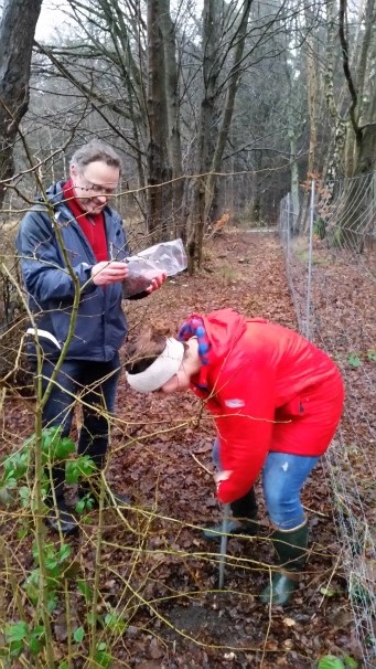
Test containers and access to meeting room
KONTAKT
Collstrop-site, Fredensborg
Jespervej 309
3480 Fredensborg
Anna Toft
Region Hovedstaden
T: 38665628
E: anna.toft@regionh.dk
Site owner:
Danish Nature Agency
PRÆSENTATION AF SITET
BEGRUNDELSE FOR SITET
The site is heavily contaminated with the heavy metals arsenic, chromium and copper. In 2015, there was limited knowledge on suitable techniques for remediation or immobilization of large scale heavy metal contaminations. The Collstrop site is part of a government owned wood and is easily accessible. In light of the nature of the contamination and the easy access, the Capital Region and Danish Soil Partnership saw it as a good site for testing techniques that can be used for remediating or immobilizing heavy metals at this site and others.
In December 2015 the Capital Region and the Nature Agency agreed to transfer the right to use the site to the region for a period of five years so far. In January 2016 a temporary test facility was moved closer to the heavily contaminated part of the site and made more permanent.
GEOLOGI
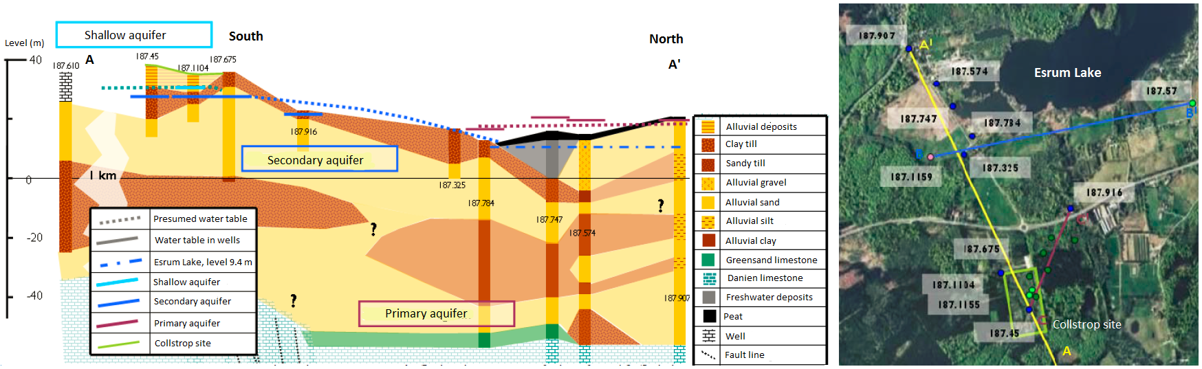
The site is characterized by complex glacial formations located on the edge of a buried valley.
The top soil at the site is 1-5 meters of varied alluvial clay-mixed sand. This formation contains a shallow ground water aquifer with several hanging water tables on clay lenses in the sand. The actual water table is about 3 m bgs.
Beneath the shallow aquifer is a clay till layer of varied thickness (4-19 meters). This layer is found in all boreholes at and around the site. Below the upper clay till is a layer of relatively homogenous alluvial sand, described as the secondary aquifer. This layer is assumed to be 20-40 meters thick beneath the site. There are indications of a leakage through the upper till to the secondary aquifer at the northeastern corner of the site, although the latest report (Danish EPA 2011) disputes this.
Beneath the secondary aquifer is a lower clay till layer of 13-40 meters, succeeded by a lower alluvial sand layer on top of limestone. The lower sand and limestone layers constitute the primary aquifer used for drinking water. The lower clay till layer separating the secondary and primary aquifers is found in all deep wells around the site, and there is a downward gradient between the two aquifers.
The groundwater flow direction in the shallow aquifer is mainly to the east towards a network of ditches east of the site. The flow direction in the secondary aquifer is north-northeast towards Esrum Lake. The flow direction in the primary aquifer is uncertain but is assumed to be under Esrum Lake.
Click on the figure below (from DTU's report) for an overview of the general geological and hydrogeological setting at the site.
FORURENINGSSITUATION
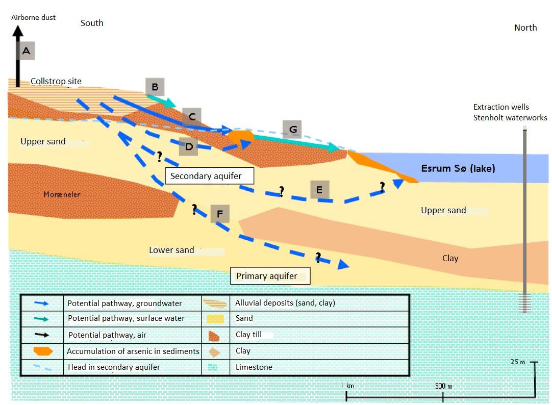
The site is heavily contaminated with the heavy metals chromium, copper and arsenic (CCA for short), which were used for wood impregnation at the site between 1936 and 1976. The contamination is widespread across the area as a result of both direct spill and dripping and of spreading highly contaminated bark.
The soil contamination is highest in the top soil, from the surface to about 4 meters for arsenic and to about 0.5 meters for chromium and copper. Typical concentrations in the top soil are up to 20,000 mg/kg for arsenic, up to 30,000 for chromium and up to 7,000 mg/kg for copper. The contaminant mass has been estimated to 44 tons of arsenic, 5 tons of chromium and 7 tons of copper. Copper is toxic to plants, so the hot spots of copper are easy to see as moss-only covered areas in the woods.
The site also contains areas with contamination of oil products in the top soil.
Precipitation has washed out heavy metals to the underlying shallow aquifer. In the shallow aquifer have been detected high concentrations of arsenic under the site, and significantly lower concentrations downgradient of the site, towards the ditch network east of the site. Concentrations of CCA in the secondary aquifer are on level with background values. There are no wells screened in the primary aquifer at the site, but concentrations in downgradient water supply wells are at background levels.
The shallow aquifer is drained to a ditch network east of the site, and the arsenic has been shown to precipitate in the sediment, which causes soil concentrations between 100-1,300 mg/kg in the ditches. The surface water borne transport of arsenic to downstream Esrum Lake is at natural background level. Starting in 1996, the ditch sediments have been routinely dug up to remove precipitated arsenic.
The contamination transport from the site is extremely slow due to the low mobility of the critical contaminants. Concentrations in the secondary and primary groundwater as well as in streams towards Esrum Lake are at background levels, so no recieving waters are immidiately threatened. In 2016 the Capital Region monitors concentration levels in surface waters, sediments and groundwater to verify the contaminant transport from the site. The entire area is fenced off to the public to avoid contact with contaminated top soil.
Click on the figure below (from DTU's report) for a conceptual site model with a summary of the potential contamination patrhways. Pathway C is the only documented pathway at the site.
For further information about the contamination and risk assessment, please consult the reports in the Technical documents section.
PRAKTISK
Adgang til sitet
How to get there and where to park:
The test site is located in the woods, on the outskirts of the fenced-off contaminated area. Please consult the map and directions on how to get there.
Entering the site:
The test site and the containers are locked with former Frederiksborg County padlocks. If you do not have a key, one can be found in the key box at the container site gate. The key box is combination locked. Please contact the region’s site administrator for the combination. Remember to return the key to the key box after use and scramble the lock.
Using the meeting room at Eghjorten:
You need to make arrangements with the site administrator or the Nature Agency ranger to use the meeting room. The site administrator can instruct you on how to receive a key outside normal opening hours.
How to book test space and the meeting room:
Capital Region employees:
Send an Outlook meeting request to CRU-FP-Collstrop specifying the space requested and the activity. See the available test space numbers in Infrastructure for testing below. The booking is confirmed when the administrator accepts the request.
External partners:
Talk to your Capital Region contact or the site administrator to make the booking.
Heavy vehicles:
A new forest road has been constructed in the summer of 2016, allowing for heavy vehicle traffic to the container site. Access the site from the south, as shown in the map and directions.
Faciliteter
The test site is currently a collection of containers in the woods, so the comfort level is generally low. However, we are allowed to use the cabin and toilets of the Nature Agency's "nature helpers" at the Eghjorten nature school, about 200 meters north of the test site.
At the Nature Agency's cabin, there is a room for coffee breaks and a meeting room that fits about 20. Remember that we are guests at the cabin, and use of the meeting room must always be coordinated with the region's site coordinator or the local Nature Agency ranger (currently Martin Wiberg: +45 7254 3302, mawib@nst.dk).
The region plans to have a personnel trailer with limited office space and toilet at the container site in periods when the site is used more intensively. There is regular and high voltage power at the test site but no telephone or network. We will install wireless internet conncetion in the personnel trailer, if needed.
Test infrastruktur
How to get there and where to park:
The test site is located in the woods, on the outskirts of the fenced-off contaminated area. Please consult the map and directions on how to get there.
Entering the site:
The test site and the containers are locked with former Frederiksborg County padlocks. If you do not have a key, one can be found in the key box at the container site gate. The key box is combination locked. Please contact the region’s site administrator for the combination. Remember to return the key to the key box after use and scramble the lock.
Using the meeting room at Eghjorten:
You need to make arrangements with the site administrator or the Nature Agency ranger to use the meeting room. The site administrator can instruct you on how to receive a key outside normal opening hours.
How to book test space and the meeting room:
Capital Region employees:
Send an Outlook meeting request to CRU-FP-Collstrop specifying the space requested and the activity. See the available test space numbers in Infrastructure for testing below. The booking is confirmed when the administrator accepts the request.
External partners:
Talk to your Capital Region contact or the site administrator to make the booking.
Heavy vehicles:
A new forest road has been constructed in the summer of 2016, allowing for heavy vehicle traffic to the container site. Access the site from the south, as shown in the map and directions.
Krav til projektejere
Visitors:
Generally we ask that you treat the facilities with respect and clean up after yourselves. When using the coffee room or meeting room at Eghjorten, always leave the place in the same condition that you received it.
Project owners:
If you wish to use the facilities to test a method “on your own” (i.e. the region is not involved in the test), you are welcome to do so. We ask you to sign an agreement, which commits the project owner to take responsibility for any damages under Danish law and for not increasing the cost of future public efforts to remediate the contamination. Here you can find a template for the agreement.
Igangværende projekter
Electrodialytic remediation of chromium, copper and arsenic
Pilot test of electrodialytic remediation of copper, chromium and arsenic (CCA) from Collstrop soil.
The first pilot study, financed by the Capital Region of Denmark, was completed and reported in January 2016 - see the Technical note and the Executive summary.
The first pilot study pointed toward a number of possible improvements to the method. DTU researchers continue the pilot scale experiments at the Collstrop site from late Spring 2016.

Partnere


Graphite-stimulated electrodialytic remediation
Soil samples collected from Collstrup are used in a lab-scaled electrodialytic remediation (EDR) experiment. The purpose of this experiment is to remove heavy metals (Cu, Cr, As) from the contaminated soil by a new EDR system. This new EDR is developed by adding graphite particles into soil repair chamber between two main electrodes. Those added graphite particles will be polarized and act like micro electrodes during EDR process, which is believed to be helpful in improving mass transfer. It is expected to be more efficient than conventional EDR process in remediating this soil and reducing its potential hazard to the environment.
The experiments are conducted by DTU Civil Engineering
Partnere

Microbiological and Molecular Tools for Remediation of Metal-Polluted sites
This is a PhD-project carried out by Stacie Tardif from Copenhagen University, Plant and Environmental Science, under the REMEDIATE program. The project is supervised by Kristian Koefoed Brandt.
The objective is to investigate the long-term effects of Chromium/Copper/Arsenic (CCA) contamination on soil microbial community composition, function, metal resistance and permissiveness for plasmid uptake. Another aim is to develop and apply more predictive, ecologically relevant methods for assessing soil contamination and remediation efforts.
For more information and expected time schedule, see the attached short project description.
Partnere

Projektdokumenter
Kommende projekter
Electrodialytic remediation of Norwegian harbor sediment
Partners: Danish Technical University
Time frame: Possibly Summer 2016 -